|
Cross-Country Route 40 Bike Trip - Day 14: Kremmling to Idaho Springs, Colorado
| Distance: |
82.0 miles |
| Description: |
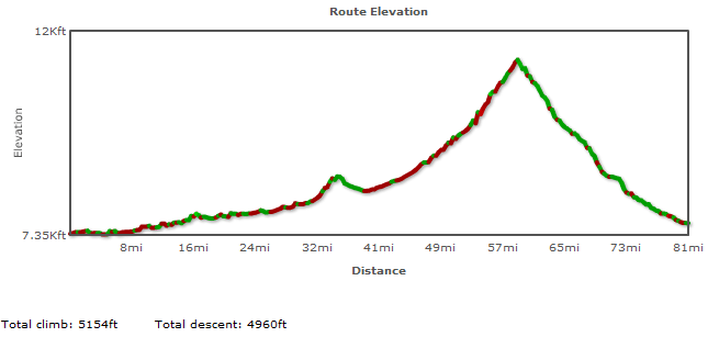
This is probably the toughest day of the entire Route 40 cross-country trek. The first 60 miles cover a rather brutal ascent of more than 4,000 feet in elevation. Once you reach the summit of Berthoud Pass (the highest point on all of Route 40), you will rapidly descent about 4,000 feet in about 20 miles. |
| Details and Map: |
Bikely.com |
|
|
 |
| GIS Data Files: |
Google Earth (KML) | GPX |
Important Notice: Please note that if you elect to follow this itinerary, you do so at your own risk. Failure to exercise good judgment can result in traffic violation citations, injury and even death. I can assume no responsibility for any errors in this information, nor can I be held responsible for anything that may occur while traveling along this route. If you are unsure about the legality of pedestrian travel along any of the roads described here, please consult with state and local law enforcement agencies.
View user comments below.
For more information:
No comments have been posted.
Feedback: Do you have corrections or contributions for this page? Want to make a suggestion? Click here to send me an e-mail. I am espcially interested in memories, stories, postcards and photographs. Thanks!

Last updated: 2009-11-23 05:35:10 |
|
|

|
|