Part 3
Previous Page | Next Page | Introduction | Part 1 | Part 2 | Part 3 | Part 4 | Part 5 | Part 6
From the point of intersection with the National turnpike, one-fourth mile west of Alleghany Grove, the Braddock Road keeps north of the turnpike on somewhat higher ground to escape swampy land; thence, in order to avoid the point of a hill (or perhaps it would be more accurate to say a spur of Piney Mountain), it crosses the turnpike to the southward, and after running parallel to it for about 150 yards recrosses it to the northward at or near the point where the present trolley line intersects it. Here there is a well-preserved scar for almost a mile to the point where the road joins the National turnpike near the six-mile post. The route then follows along the north side of the turnpike, crossing Braddock Run, a little to the north of the bridge;[26] thence running westerly north of the Six Mile Rouse, it recrosses Braddock Run, and a few rods beyond passes between the house and barn of Charles Laber. On this farm there is a copious spring of excellent water, locally known as Braddock Spring,[27] situated about 175 feet south of Braddock Road, and according to local tradition marking the site of Spendelow Camp. That this theory is altogether unlikely, however, is shown not only by the fact that the tradition does not harmonize with the best authorities, but also by the topography of the country and the lack of sufficient and suitable ground for an encampment. That an advance party may have spent the night at or near this fine spring is not improbable, but the natural place for the camp was in the neighborhood of Alleghany Grove Camp Ground.[28]
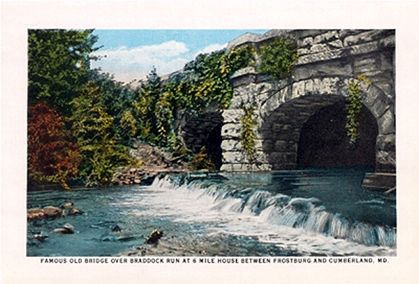 |
| 6-Mile Bridge over Braddock Run. |
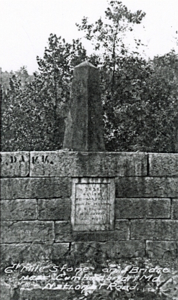 |
6th Milepost over Braddock Run. |
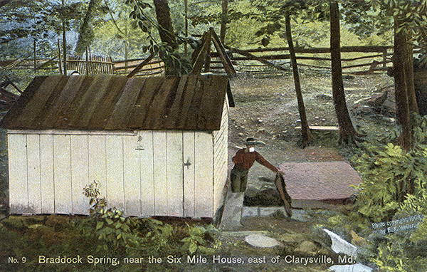 |
Braddock Spring, near the Six Mile House, east of Clarysville, Md. The tradition is that in and around this spring the first encampment - "Spendelow Camp." The topography of the country and the lack of sufficient and suitable ground for an encampment, together with the fact that it does not harmonize well with the chief sources, make it very questionable. That an advanced party may have encamped at or near this magnificent spring is more than probable, but the natural place for the camp would seem to be in the neighborhood of Allegany Grove. [Lacock] |
| |
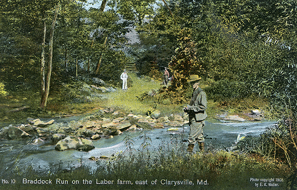 |
Braddock Run on the Laber farm, east of Clarysville, Md. Less than one-half mile west from Charles Laber's farm crosses Braddock's Run. The run is about 30 feet wide, very deep, and with strong current. The road from this point to Clarysville, some two miles distant, is excessively mountainous and rocky. [Lacock] |
Less than a quarter of a mile west of Charles Laber's house Braddock Road again crosses Braddock Run; thence turning almost due south in order to avoid a rocky ascent over which no road could be built, it comes into the National turnpike about a mile west of the old toll-house. From this point it coincides with the turnpike for 225 feet; then it veers away to the north for some rods and turns west, crossing the county road known as the Short Gap road about fifty yards north of its junction with the turnpike, and passing the house now owned by John Laber. A short distance west of this point it crosses the turnpike and the Eckhart branch of the Cumberland and Pennsylvania Railroad in order to avoid a very deep hollow, and joins the pike again four hundred feet farther on. After following the old turnpike for about one hundred feet it veers away again to the north of it at Spruce Bridge for about three-quarters of a mile, passing Smith's Big Rocks, and joining the turnpike again less than quarter of a mile east of Clarysville. From Alleghany Grove Camp Ground to Clarysville there are only a few short stretches where traces of the road cannot be distinctly seen, and in some places the scar is nearly ten feet deep.
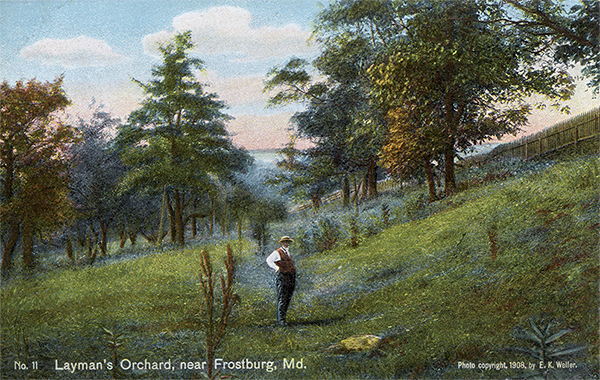 |
Layman's Orchard, near Frostburg, Md. From Clarysville, Braddock's Road follows the head waters of George's Creek, thence up Hoffman Hollow. Beyond Hoffman, at the top of the hill, the road turns almost due north in order to avoid a very wide swamp. Layman's orchard lies less than one-half mile south-east of Frostburg. North of this orchard is the second encampment which was termed the "Camp at Martin's Plantation." [Lacock] |
| |
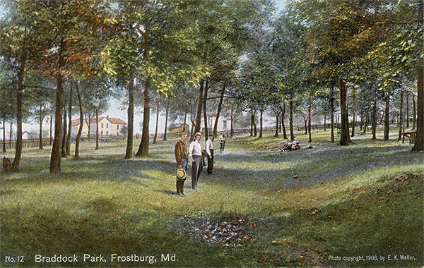 |
Braddock Park, Frostburg, Md. On June 15, the entire force moved from Martin's Plantation and passed through the southern part of Frostburg, where the first traces of the road through the town can be seen in the lot of James Grose. Thence the road passes westward through Braddock Park. About 150 yards north of this park is an old mile stone. [Lacock] |
At Clarysville the road turns in to the valley of Flaggy Run, apparently following the west bank of the stream,[29] along which there is a deep depression formed by an old mill race that might easily be mistaken for the road itself. About half a mile southwest of Clarysville the road turns almost at a right angle, keeping approximately the course of the present county road for three-quarters of a mile up Hoffman Hollow. Here again, running parallel to the present road, is an old tramway roadbed which might readily be taken for Braddock's path. A short distance beyond the Hoffman coal mines, on the north side of the road, is a very deep scar, which is probably a part of Braddock's roadbed. At the top of the hill the road turns northward at almost a right angle in order to avoid what was formerly a very wide swamp, and then passes over the ridge and down through Layman's orchard, where there is a deep scar. Near the end of this ridge, overlooking Frostburg and about five miles from Spendelow Camp, is the site of the second encampment, Martin's Plantation.[30]
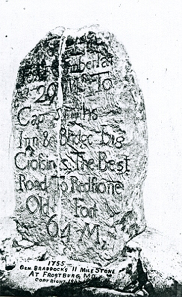 |
The so-called Braddock Milestone. |
From here the road crosses first the headwaters of the eastern branch of George's Creek, next the Cumberland and Pennsylvania Railroad, and then runs southeast of Frostburg into the premises of James Grose, and on through the Sheatz, Taylor, and William Tiley properties to Braddock Park. About 350 feet north of this park is an old milestone, which is supposed by some writers to have been set up by Braddock.[31] Leaving Braddock Park the line follows the Midlothian road for about four hundred feet; but, soon entering a lane, it crosses the western branch of George's Creek east of an old spring-house standing near the ruins of the old Musselman farmhouse, and bearing the inscription ''C. & S. Musselman, May 30th, 1806.' At this point, one-fourth mile west from Braddock Park, the ascent of Big Savage Mountain begins. Although there are some level spots on the western slope of the mountain, the ascent of more than two miles is very steep and rocky, and the cut is several feet deep in places.[32] The descent for a half mile or more is also very rugged and in places extraordinarily steep.[33] On the east and west slopes the traces of the route are very distinct.
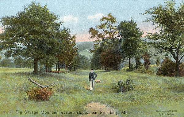 |
Big Savage Mountain, eastern slope, near Frostburg, Md. About one-fourth mile west of Braddock Park, Braddock's Road begins an ascent of [Big Savage] Mountain, just north of an old spring-house which bears the following inscription: "C. & S. Musselman, May 31th, 1806." [Lacock] |
Footnotes
[26] From this point to Clarysville the route is through a gap between Dans Mountain and Piney Mountain.
[27] This spring is about one-third of a mile west of the tollgate on the National turnpike.
[28] Although many misstatements and untenable notions as to the location of the road, the places of encampment, etc., are prevalent in the country adjacent to the line of march, yet local tradition is in many cases surprisingly accurate.
[29] See Middleton's map.
[30] Orme Journal, 333.
[31] See Lowdermilk's History of Cumberland, 257. This stone, sometimes designated Braddock's Stone, bears the following inscription: '11 miles To Ft Cumberland 29 Ms To Captn Smyth's Inn and Bridge Big Crossings & The Best Road To Redstone Old Fort 64 M.' This is fairly legible. The other side reads, 'Our country's rights we will defend.' There is no reason for supposing that this stone was erected by Braddock's command.
[32] On the summit of the mountain, a few hundred yards to the north of the road, is St. John Rock, 2930 feet above sea level, from which a magnificent view of the surrounding country is to be had.
[33] Three wagons were entirely destroyed in passing this mountain, and several more were shattered (Orme Journal, 335).
Previous Page | Next Page | Introduction | Part 1 | Part 2 | Part 3 | Part 4 | Part 5 | Part 6
View user comments below.