Part 4
Previous Page | Next Page | Introduction | Part 1 | Part 2 | Part 3 | Part 4 | Part 5 | Part 6
At the foot of the mountain the road unites with a highway a little to the east of Andrew Jackson Moore's stone house, and continues with it for nearly half a mile, when it apparently turns into a private or secondary road for about another mile to a point where there is a favorable place for fording Savage River, the last water that empties itself into the Potomac.[34] Near a schoolhouse on the north bank of Savage River and a short distance west of the mouth of Carey Run the road begins a very steep ascent of Little Savage Mountain. From this point to the Henry Blocher farm, a little over a mile westward, the course of the road follows closely that of a private way, on either side of which there are for short intervals very clear signs of the location of Braddock Road. From various indications it seems reasonable to conclude that the farm of Henry Blocher, with the adjoining one of George Blocher, marks the location of Braddock's third encampment, Savage River Camp.[35] There is a local tradition that about five hundred yards west of the Henry Blocher farm a skirmish with the Indians took place, and that near a clump of trees east of Blocher's house some British soldiers were buried.[36]
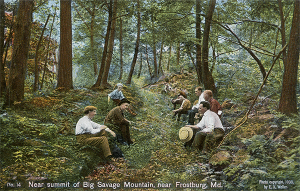 |
Near summit of Big Savage Mountain, near Frostburg, Md. While there are level spots on the eastern slope of the mountain, yet the ascent is rocky as the picture shows, and in many places, extremely steep. The descent is very rugged, and at places almost perpendicular. On the western slope slows Big Savage River. [Lacock] |
| |
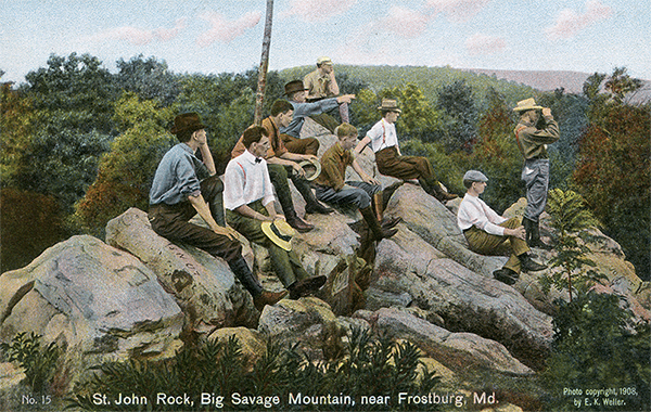 |
St. John Rock, Big Savage Mountain, near Frostburg, Md. The U.S. Geological Survey on the topographical sheet, use the term "rock" instead of "rocks." These rocks near the summit of the mountain, one-fourth mile northwest of Braddock's Road. The elevation is 2930 feet. A most magnificent view of the surrounding country is to be had from these rocks. [Lacock] |
| |
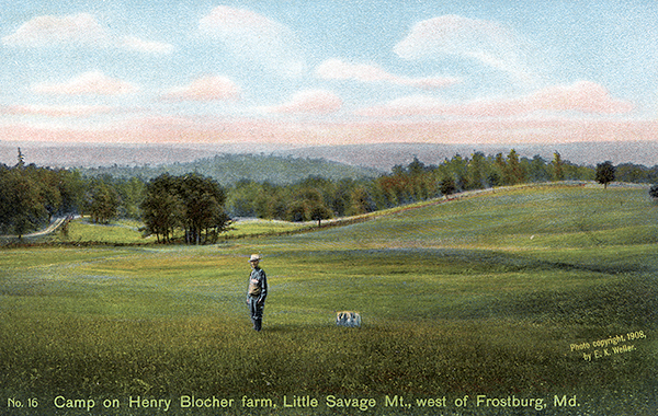 |
Camp on Henry Blocher farm, Little Savage Mt., west of Frostburg. Near the mouth of Carey Run, and close by a school house, the ascent of Little Savage Mountain begins. Considerably less than two miles from this point one reaches the farm of Henry Blocher. Near the clump of tress (see photo) some British soldiers are said to be buried. This is the most likely spot for the third encampment - "Savage River Camp." [Lacock] |
From the Henry Blocher farm the line follows the general course of a private road westward for about a mile, crosses Mudlick Run to Read Anderson's house, and thence leads up a rather formidable hill, on which Braddock's engineers appear for the first time to have made use of a winding path as a means of ascent. From this hill the road runs by very favorable ground in a nearly straight line to the corner of a wood, and then on through the woods to a township road, which it crosses at a point about a quarter of a mile from the National turnpike. Proceeding in the same straight line westward less than quarter of a mile, it reaches and crosses the turnpike to the north. It was at or near this intersection that the first brigade probably encamped on June 15.[37]
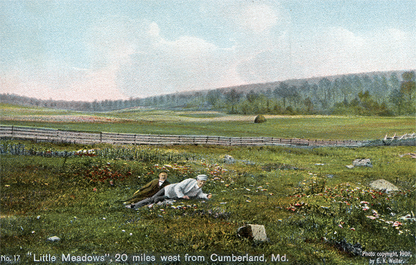 |
"Little Meadows", 20 miles west of Cumberland, Md. The Little Meadows Farm of over 1200 acres is now owned by D. F. Kuykendall, Cumberland, Md. This is the place of the fourth encampment. On June 18, 1755, the entire force had reached "Little Meadows." Here, at a council of war, it was determined that the General and Colonel Halket, with a detachment of the best men of the two regiments, being in all about 1400, lightly encumbered, should move forward. Colonel Dunbar with the residue, about 900, and the heavy baggage, stores, and artillery was to advance by "Slow and easy marches." (See Cumberland Road Series) [Lacock] |
| |
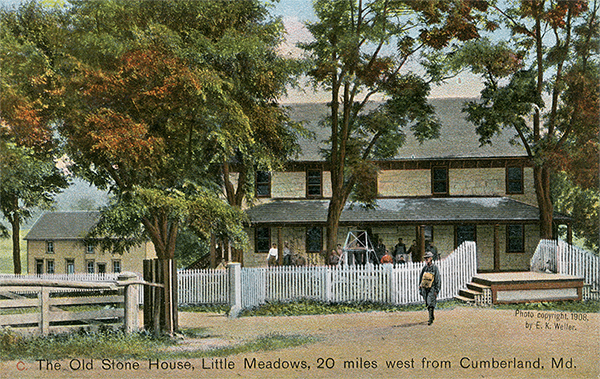 |
The Old Stone House, Little Meadows, 20 miles west from Cumberland. One Jesse Tomlinson formerly owned "Little Meadows" and kept a tavern on the old Braddock Road. Then the National Road was opened he built a new house, which is located at the foot of Meadow Mountain, two miles east of Grantsville. The Old Stone House now belongs to D. T. Kuykendall. (See Braddock Road Series, No. 17) [Lacock] |
From this point to some woods less than a quarter of a mile westward there is no trace of the road, but through these woods there is a well-marked scar for over half a mile to Two Mile Run. Near this stream are the renowned 'Shades of Death,' once a deep forest the tops of whose towering trees intertwined.[38] From the 'Shades of Death' the road passes up Red Ridge, crossing another road a few rods to the north of a house now occupied by Henry Meerbach;[39] thence it runs to Wolf Swamp and Red Run,[40] and on to the foot of Meadow Mountain.[41] On the east and west slopes of this mountain the cuts, from six to ten feet deep, are for long distances clearly perceptible. On the western slope the beautiful estate of Little Meadows, now owned by D. F. Kuykendall, of Cumberland, marks the location of the fourth encampment.[42]
A short distance from Little Meadows the road crosses Chestnut Ridge. Thence proceeding westwardly, it intersects the National turnpike about one mile east of the Little Crossings bridge over the Castleman River, runs through the farm of Eli Stanton, where there is a very clear scar, and then crosses the Jennings Brothers' railroad.[43] A quarter of a mile farther westward it intersects the National turnpike near Stanton's old mill; but, after following the turnpike very closely for a few rods, it veers off to the south, crossing the Castleman River about three hundred yards above the Little Crossings bridge, near a point locally known as Hickory Hole. On the west side of the river the road veers away to the southwest, and a few rods from the fording enters some woods, in which the scar is well marked. Thence turning westward it passes about a quarter of a mile south of Grantsville, and continues in an approximately straight line to Shade Hill, which shows a scar as deep as any on the mountain ranges previously mentioned.[44] At the foot of the western slope of this hill the road crosses Big Shade Run; and a short distance westward, near Little Shade Run, it passes the house and barn now owned by John P. Miller. This was the place of the fifth encampment.
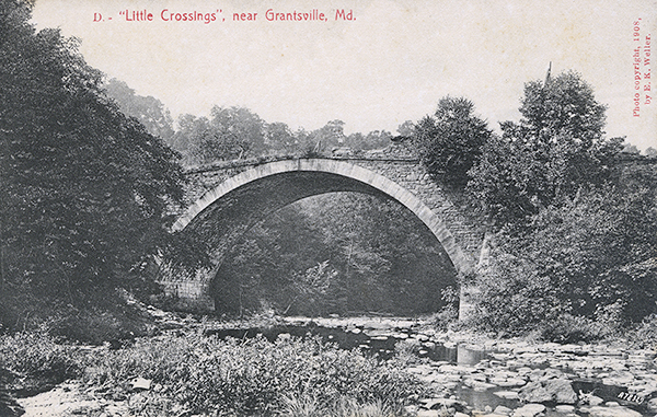 |
"Little Crossings", near Grantsville, Md. This bridge is over the Castleman river just east of Grantsville (Md.). It is said to have been the largest single span bridge of rubble stone masonry in the United States at the time it was built. It is a magnificent structure but is badly out of repair. [Lacock] |
| |
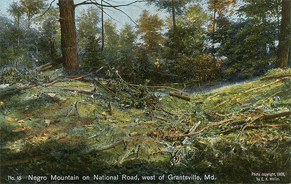 |
Negro Mountain on National Road, west of Grantsville, Md. Near a stone quarry on the National Pike, one fourth mile west of Mile Stone "104 to Wheeling to Frostburg 16," the Braddock Road crosses the National Pike on Negro Mountain. A sort of traverse road was cut over this mountain. The scar on the mountain is quite marked. [Lacock] |
At this point, in plain view of the National turnpike, the road begins the ascent of Negro Mountain. Following a distinct trace for about a mile, the traveller reaches the farm now owned by G. W. Shaw. The road passes north of his house; and, at a point a quarter of a mile to the westward and about the same distance south of the National turnpike, it intersects a country road which extends northward to the turnpike. Continuing from this point in the same straight line, it crosses the turnpike one-fourth of a mile west of a milestone which bears the inscription ''104 to Wheeling To Frostburg 16.'[44a] Up the mountain for a distance of less than a mile the scar of the road is clearly seen, as far as the north fork of Spiker Run on the eastern slope. From this point, again, the line is easily followed westward for more than half a mile, until it passes immediately south of the Oak Grove or Mennonite church; but from here to the place at which it intersects the National road on the eastern slope of Negro Mountain, at a lane east of the house of H. C. Butler, there are but slight traces.
Footnotes
[34] It is an interesting fact that throughout the route the fording of a stream was in every case at or slightly below the mouth of a tributary. At such a place there is usually a riffle caused by the formation of a bar of sand, gravel, and mud, the crest of which offers a very practical opportunity for fording. Some of the apparent deviations of the road from what would seem to have been the natural course may have been made for the sake of avoiding a depth of water which might have rendered the streams impassable except by bridging. In other instances a circuitous route may have been the most practicable way of passing a swamp or a bog.
[35] Orme Journal, 335.
[36] Orme mentions no encounter with the Indians at this place of encampment.
[37] According to Orme, the first brigade encamped about three miles west of Savage River (Orme Journal, 335), a location which corresponds with that suggested shore. This spot, furthermore, is the only advantageous ground in the vicinity.
[38] Dense forests of white pine formerly covered this region, which, from the deep gloom of the summer woods and the favorable shelter that the pines gave to the Indian enemy, came to be spoken of as the 'Shades of Death.' The writer's party was told that the old wagoners who used to drive from Baltimore to Zanesville dreaded this locality as the darkest and gloomiest place along the entire route. Of the former gloomy forest, however, nothing now remains except the stumps. The trees were cut down years ago, sawed up, and shipped to market.
[39] From Mrs. Henry Meerbach the writer secured two English pennies bearing date of 1724 and 1753 respectively, which, she said, were picked up on Braddock Road on the eastern slope of Meadow Mountain.
[40] This is doubtless the bog to which Orme refers as having ''been very well repaired by Sir John St. Clair's advanced party with infinite labour' (Orme Journal, 335).
[41] This mountain, it may be noted, constitutes the dividing ridge between the waters that flow into the Atlantic and those that enter the Gulf of Mexico.
[42] Orme Journal, 335. The Little Meadows farm at present consists of over 1200 acres. At the time the National turnpike was laid out Jesse Tomlinson owned the land at this point and kept a tavern on Braddock Road. The Tomlinson estate was, indeed, one of the objective points for the turnpike as specified in the first report of the commission appointed to lay out the National road, then uniformly known under the legal name of Cumberland Road (Executive Document, 9 Cong., 2 sess., Jan. 31. 1807, 16 pp.). On June 15, l755, the entire force had reached Little Meadows, where at a council of war it was determined. That General Braddock and Colonel Halket, with a detachment of the best men of the two regiments (in all about 1400, lightly encumbered), should move forward. Colonel Dunbar with the residue (about 900), and the heavy baggage stores. And artillery, was to advance by slow and easy marches.
[43] A t this point it may be well to clear up an obscurity likely to arise from a confusion of the following names: Little Meadows is at the western slope of Meadow Mountain, twenty miles from Cumberland; Great Meadows, which marks the site of Fort Necessity, is about thirty-one miles farther west; Little Crossings is a ford of the Castleman River just east of Grantsville and two miles west of Little Meadows; Great Crossings is the passage of the Youghiogheny about half a mile shove Somerfield and sixteen miles west of Little Crossings.
[44] This is the only region on the entire route in which pine trees in any considerable quantity still remain.
[44a] [Brusca footnote: Lacock is in error on the milepost mileage. It should read '104 to Wheeling 27 to Cumberland.']
Previous Page | Next Page | Introduction | Part 1 | Part 2 | Part 3 | Part 4 | Part 5 | Part 6
View user comments below.