|
"Braddock Road" by John Kennedy Lacock (1909)
Part 5
Previous Page | Next Page | Introduction | Part 1 | Part 2 | Part 3 | Part 4 | Part 5 | Part 6
Along this lane for half a mile through slightly rolling depressions the road runs on to Puzzley Run, and after fording the run passes with a distinct scar north of a vacant log house over a very difficult pass to a lane east of William Augustine's house, and thence along this lane for several rods to the house, which is built on the very roadbed itself and less than one hundred yards from the National turnpike. From Augustine's house the line runs parallel to the turnpike, but a few rods south of it, for over two miles to Coon Spiker's house, showing here and there traces of the road that are more or less distinct. Apparently passing south of this house and on through a lane to the south of Stephen Spiker's house, it presently, a little to the westward, enters a stretch of woods, through which it proceeds over Keyser Ridge, where, although there is a very luxuriant growth of underbrush, the trace of the road for a little over two miles is so distinct as to leave no doubt in regard to its course over this rocky and very difficult pass. From the woods it emerges into the bottom of the north fork of Mill Run, less than half a mile from the Pennsylvania and Maryland boundary line at Oakton, Maryland.[45] Here, in one of the most picturesque places for an encampment along the entire route, was Bear Camp.[46]
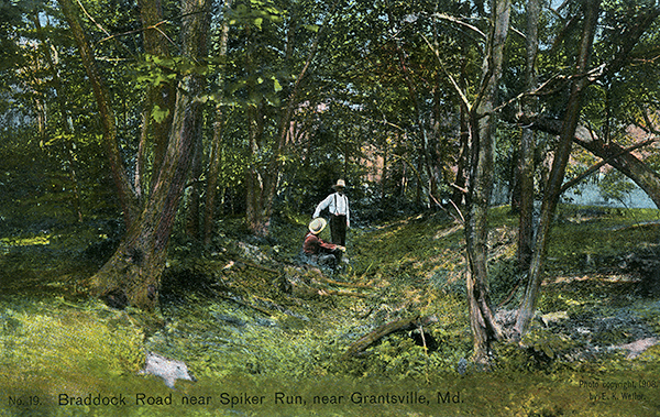 |
Braddock Road near Spiker Run, near Grantsville, Md. Less than one mile west from the point at which Braddock's Road intersects with the National Road on Negro Mountain is the north fork of Spiker Run, a branch of the Castleman River., on the eastern slope of Negro Mountain. Less than one mile east is The Oak Grove or Menonite Church. The photo shows a very distinct scar of the road. [Lacock] |
| |
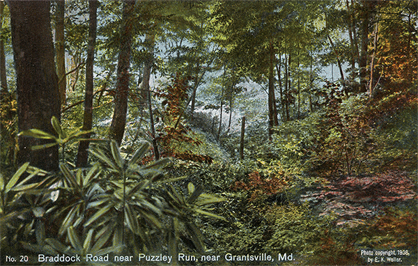 |
Braddock Road near Puzzley Run, near Grantsville, Md. The Braddock Road recrosses the National Road on Negro Mountain at a lane east of the house of H. C. Butter, less than one half mile east of Puzzley Run. In the lower left hand corner is a good specimen of the rhododendron. [Lacock] |
| |
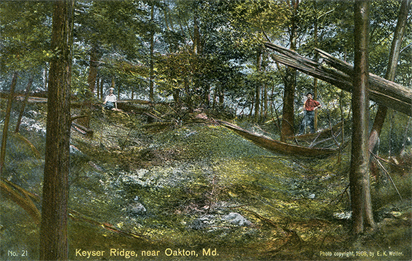 |
Keyser Ridge, near Oakton, Md. There is no other part of the old Braddock Road which presents such difficulties to the traveler as that portion of it over Keyser Ridge. The underbrush is so thick in places that one is compelled to crawl in order to keep the road. This mountain chain is very rocky and the passes are extremely difficult. [Lacock] |
| |
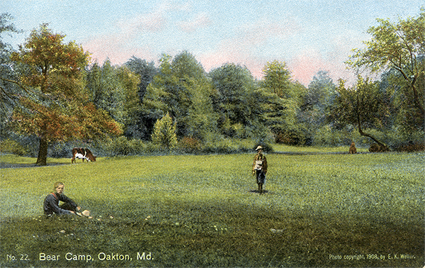 |
Bear Camp, Oakton, Md. The distance to Bear Camp - the sixth encampment - from the preceding camp, is about nine miles. Captain Orme says: "We could not reach our ground until 7 of the clock, which was three hours later than common, as there was no water, nor even earth enough to fix a tent, between the great Mountain and this place." This camp is less than one-half mile south of the Pennsylvania and Maryland boundary line at Oakton. This is one of the most picturesque places for an encampment along the entire route. [Lacock] |
| |
 |
| Braddock's March |
Leaving Bear Camp, the road, after crossing Mill Run, intercepts the Pennsylvania boundary line, and a few rods farther on crosses the National turnpike less than one-fourth of a mile west of Oakton. It then continues its course over Winding Ridge, on which the traces of it are especially well marked. On the west side of this ridge the line passes north of an old milk house and of a stone house owned by William Miller. About half a mile westward it joins the National turnpike, which it follows for nearly six hundred feet, and then veers away in a northerly direction through some woods, crossing the headwaters of Laurel nun near an old chestnut tree, two hundred yards east of Edward J. Augustine's house. From this point to Addison, a little over a mile distant, the road parallels the turnpike less than quarter of a mile to the north of it.
From Addison the course westward for nearly two miles to John Augustine's house is well defined, though only here and there does one find noticeable scars of the road. Before reaching John Augustine's house one comes to Jasper Augustine's estate, where there was formerly on Braddock Road an old hotel known as the Old Granny Welsh House, of which nothing now remains but a few foundation stones. The exact location of the point at which Braddock Road crosses the National turnpike west of John Augustine's house is not quite clear; but the line seems to turn almost due south less than three hundred yards west of his house, winding round a hill and then passing through a lane to Jacob Miller's house.[47] A short distance southwest of this house it strikes north of the north branch of Braddock Run, and about half a mile beyond comes to the forks of the run. Between these forks, and possibly a short distance westward, is the ground which formed the seventh encampment, called Squaw's Fort.[48]
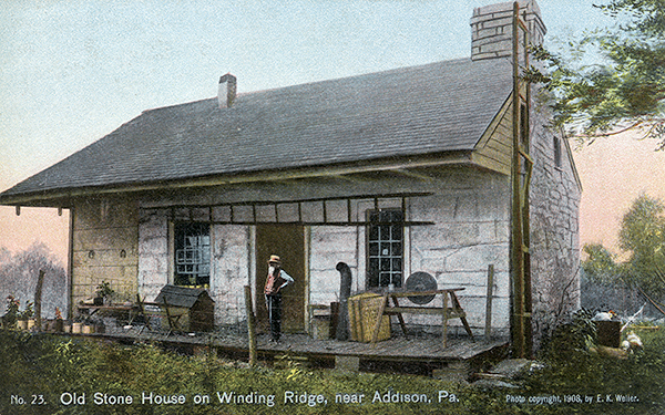 |
Old Stone House on Winding Ridge, near Addison, Pa. Winding Ridge probably derived its name from the course of the Braddock Road from Bear Camp to the Old Stone House, on the western slope, now owned by William Miller. The front part of the house was torn down some years ago. It was one of the landmarks in the early history of the old National Pike, and is situated on Braddock's Road about two miles east of Addison. [Lacock] |
| |
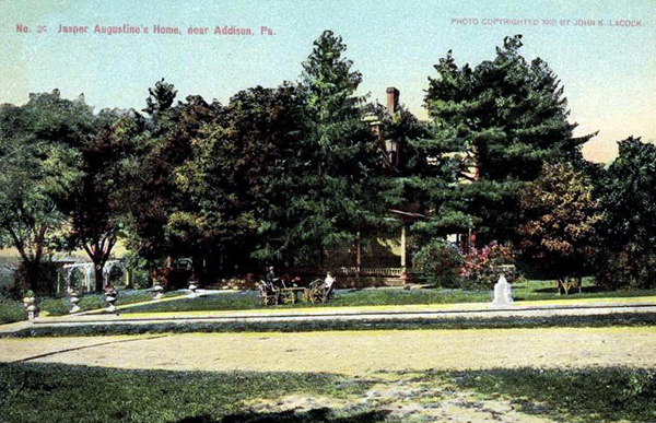 |
Jasper Augustine's House, near Addison, Pa. |
| |
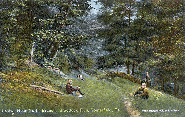 |
Near North Branch, Braddock Run, Somerfield, Pa. Braddock's Road from Winding Ridge, after keeping north of the National Road and North of Addison, crosses it west of John Augustine's house, thence turning almost due south, strikes the north fork of Braddock Run. [Lacock] |
| |
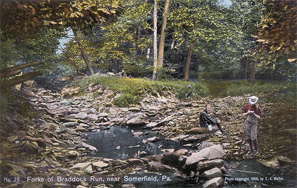 |
Forks of Braddock Run, near Somerfield, Pa. Between the forks of Braddock Run, and possibly a short distance westward, is the ground which formed the seventh encampment, designated "Squaw's Fort." This camping ground was reached on June 23, 1755. This place would certainly be an ideal place for a summer outing. [Lacock] |
| |
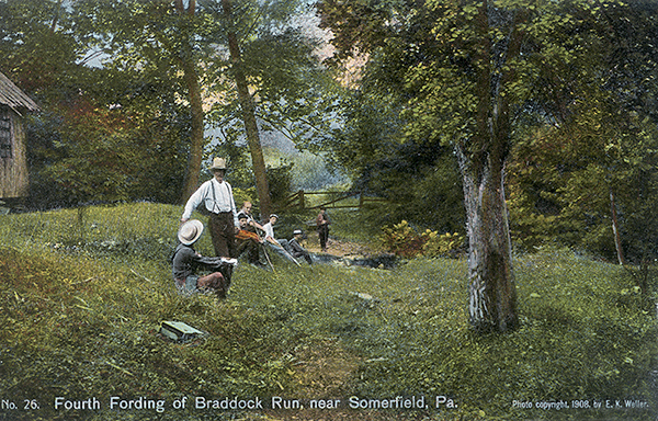 |
Fourth Fording of Braddock Run, near Somerfield, Pa. This fording of Braddock Run is a short distance from the mouth of the run. The run in this valley is very crooked, and the road crosses the run at least four times, a fact which is shown in Scull's map of 1755. [Lacock] |
| |
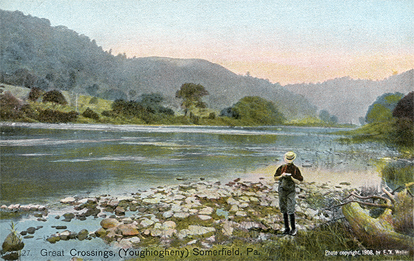 |
Great Crossing (Youghiogheny), Somerfield, Pa. General Braddock crossed the Youghiogheny on June 24. It is difficult to determine the exact fording of the river. The most natural place seems to be just below the mouth of Braddock Run. Orme says the river was "about one hundred yards wide, about three feet deep, with a very strong current." At any rate he crossed the river, without bridging, about a half a mile above where the National Road now crosses it. [Lacock] |
| |
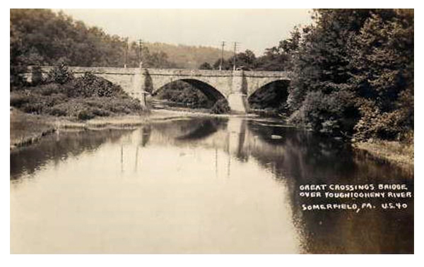 |
| Big Crossings Bridge, ca. 1930. |
From this point the road follows Braddock Run to its mouth, fording (without bridging) the Big Crossings of the Youghiogheny at or near the mouth of Braddock Run, about half a mile above where the National road now crosses the river.[49] Keeping on down the west bank of the stream, it begins a sharp ascent of Wolf, or Turkey Garden Hill, at a point opposite Somerfield, and follows the northern side of this hill for some distance before entering Jockey Hollow. The slope of the hill is very steep and the scar distinctly marked; but from Jockey Hollow onward through the valley of Potter Run there are almost no traces of the road. After keeping a little way up this run through the valley of Stuck Hollow, the line turns at almost a right angle to follow the course of a small run leading to Second River Hill, which is less than two hundred yards south of the National road. At the beginning of the ascent on the eastern slope of this hill, just at the entrance to some woods, are three distinct scars that eventually converge into one road, which runs down the western slope and a little farther on passes less than ten rods south of the house of Isaac M. Thomas.[50] A short distance westward from his house the line runs to the north of the house of A. M. Thomas, thence into a township road, then on past Charles Umble's residence to that of B. F. Miller, and a little way from this place enters the woods on Division Ridge. No other part of the old Braddock Road presents such difficulties as this section of it over Division Ridge, for the underbrush is so thick in places that one is compelled to crawl on hands and knees in order to keep the road. The slopes are very rocky and the passes are exceedingly difficult, but with plainly marked scars. At the western foot of this ridge was situated the camp of the Twelve Springs, which Orme designated as 'the camp on the east side the Great Meadows.[51]
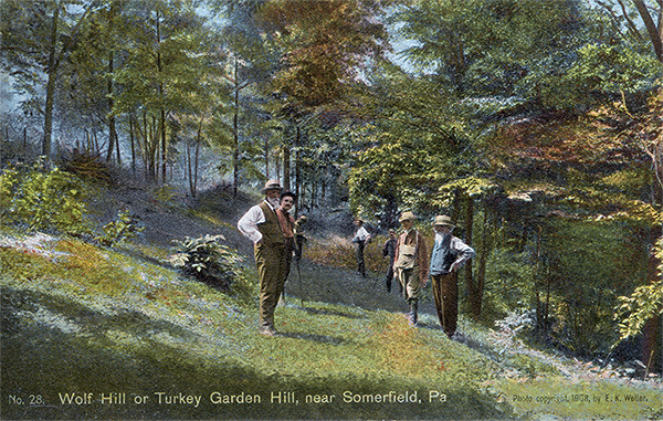 |
Wolf Hill or Turkey Garden Hill, near Somerfield, Pa. Braddock's Road follows on the north side of Wolf Hill, some distance before entering Jockey Hollow. The slope of the hill is very steep and distinctly marked. [Lacock] |
| |
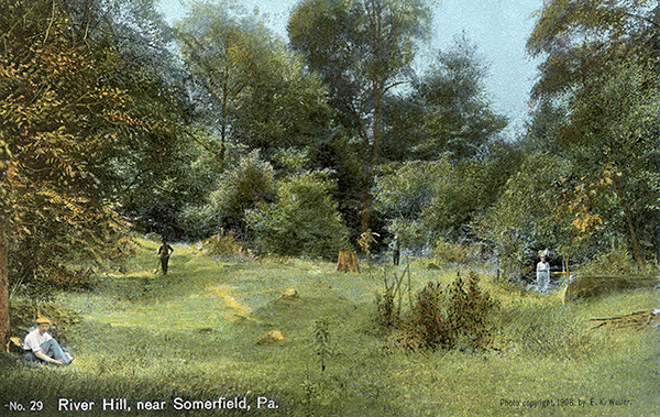 |
River Hill, near Somerfield, Pa. From Jockey Hollow the road turns into the valley of Potter Run. On River Hill (sometimes designated as Second River Hill) 200 yards from the National Pike, three distinct scars can be seen, which eventually converge into one road. [Lacock] |
| |
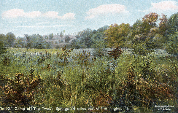 |
Camp of the "Twelve Springs", 4 miles east of Farmington, Pa.. The camp is designated by Orme as. "the camp on the east side of of the Great Meadows." This encampment of Braddock was between Mt. Augusta and Albert Landman's, about one-half mile south of the National Road, and four miles east of Farmington. [Lacock] |
| |
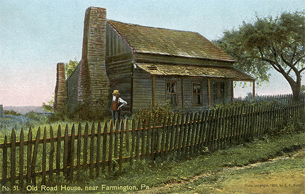 |
Old Road House, near Farmington, Pa. This house formerly belonged to Nicholas McCartney, but now owned by the Keystone Coal and Coke Company, is situated about one and a half miles south-east of Farmington. This type of house is very rare. There are very few such having the two stone chimneys on the outside. [Lacock] |
| |
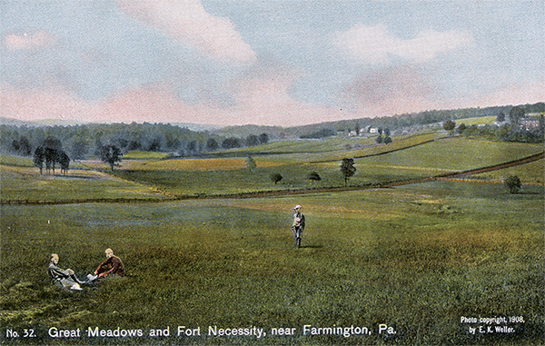 |
Great Meadows and Fort Necessity, near Farmington, Pa. July 3, 1754, George Washington was attacked by a superior force of French troops commanded by Coulon de Villiers. For nine hours, during a rain storm, Washington's little band stood the siege, and at last surrendered under the condition of marching out with the honors of war. It is noteworthy that Braddock's army passed Fort Necessity without a halt. The three trees in the photo show the location of Fort Necessity. In 1767, Washington acquired 334 acres embracing Fort Necessity, under the name of Mt. Washington, for less than $100. That portion of Great Meadows, including the site of Fort Necessity is now owned by Lewis Fazenbaker. [Lacock] |
| |
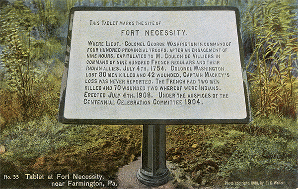 |
Tablet at Fort Necessity, near Farmington, Pa. This tablet is made of a metallic substance. It is a very suitable marker and and reflects great credit upon those under whose auspices it has been erected. [Lacock] |
From this point the road, after passing through some woods for over a mile and a half, crosses the Haydentown road near the house of Isaac Savage. About a quarter of a mile west of this place there is a large bog or swamp, a hundred or more yards across, which, if one may judge from present conditions, the expedition probably skirted to the north, and then went on westward in almost a straight line for about a mile and a half till it came to the present township road. From the camp of the Twelve Springs to this place one has very little difficulty in following the old road; but from this point onward for a little over a mile no distinct traces can be found. The most probable inferences, however, support the local tradition that the line coincides with the township road for a few rods, then crosses it north of an old burying-ground, to the east of which formerly stood an old hotel, and then, immediately rejoining it, coincides or closely parallels it for a distance of less than half a mile. At this point the road enters the farm of W. H. Hansel, and, proceeding in a northwesterly direction, presently enters a strip of woods, passes the old Bishop house (unoccupied), and then runs down Hager Hill south of James Bishop's, a quarter of a mile south of Fort Necessity.[52] For a mile and a half from the James Bishop house the road can be very accurately followed to the point at which it intersects the National turnpike, - a point, it may be noted, about a stone's throw south of the spot where lie the mortal remains of General Braddock.[53] At this intersection the road leaves the turnpike never again to rejoin it, and turns somewhat to the northwest in order to gain a favorable pass over Chestnut Ridge, the last mountain ridge to be crossed. About a quarter of a mile northward from Braddock's grave was 'the camp on the west side of the Great Meadows,'' the Orchard Camp.[54]
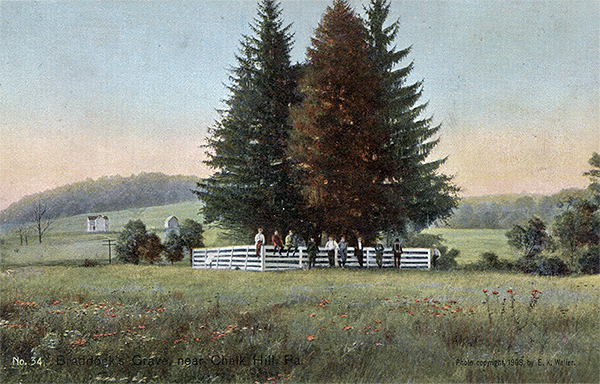 |
Braddock's Grave, near Chalk Hill, Pa. One mile east of Chalk Hill beside the National Pike, lie the remains of General Edward Braddock. Hon. Andrew Stewart is said to have caused them to be re-interred at this place in 1824; at the foot of a e large tree which disappeared prior to 1870. The grave is now enclosed in a board fence within which are a number of beautiful pine trees. (see Nos. 35 and 36) [Lacock] |
| |
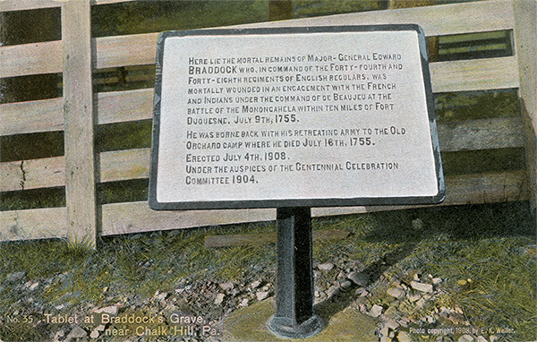 |
Tablet at Braddock's Grave, near Chalk Hill, Pa. This is made of the same metallic composition as that mentioned in No. 33. It faces the National Road, which is some twenty-five yards distant from Braddock's Grave. The Orchard Camp - the ninth encampment - was located about two miles west of Great Meadows. [Lacock] |
| |
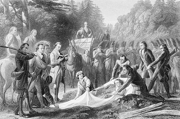 |
| Braddock's Burial. With the Chaplain incapacitated, George Washington reads from the Book of Common Prayer. |
| |
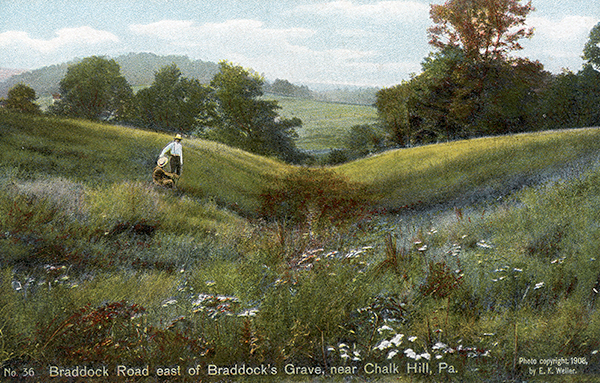 |
Braddock Road east of Braddock's Grave, near Chalk Hill, Pa. The original place of Braddock's sepulture seems to have been made on the south side of the South Fork of Braddock Run, the banks of which abruptly slope towards the stream. The grave was made in the road to prevent its discovery and desecration by the enemy. In 1824 when workmen were engaged in repairing the old road, one Thomas Faucet is said to have pointed out this place as the spot where Washington read the services on the night of July 13, 1755, over Braddock's remains. (See Nos. 34 &35)
In the distance, the Orchard Camp can be seen, designated as the "Camp on the west side of Great Meadows. [Lacock]
|
A short distance from this camp the road runs south of Nemacolin's Wigwam,[55] and a few rods northward near a schoolhouse enters the wooded part of Chestnut Ridge, on the eastern slope of which it passes the spot called Peddler's Rocks. On the western slope a sort of transverse road, the traces of which are easily followed except for about a quarter of a mile, was cut to join a township road near the house of John Henry Rankin, three miles and a half from Braddock's grave. A few rods distant on the west side of the township road are the Half King's Rocks, better known as the Great Rock, where the old camp of the Half King was located; and close by these rocks and south of the road is 'Washington Springs,' the place of Braddock's tenth encampment, called Rock Fort,[56] two miles south of Dunbar's camp.
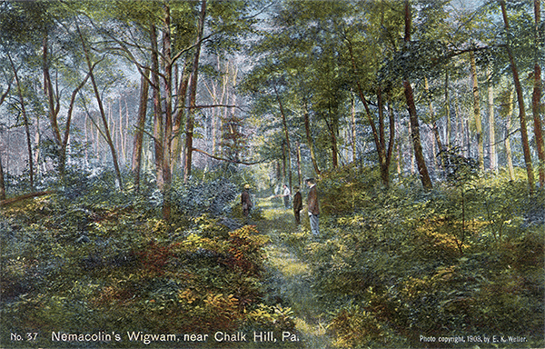 |
Nemacolin's Wigwam, near Chalk Hill, Pa. The road at Braddock's grave turned almost at angle in a northwesterly direction in order to gain a favorable pass through Laurel Hill. The photo shows the scar on Chalk Hill, about a mile north from Nemacolin's wigwam. [Lacock] |
| |
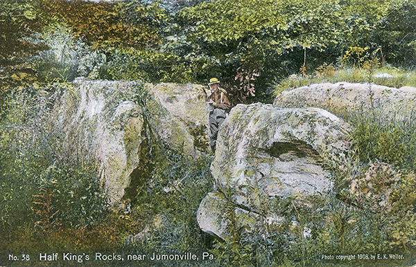 |
Half King's Rocks, near Jumonville, Pa. Orme's description of these rocks, which is so clear and exact, follows: "This Indian camp was in a string position, being upon a high rock with a very narrow and steep ascent to the top. It has a spring in the middle, and stood at the termination of the Indian path to the Monongahela, at the confluence of Red-Stone Creek." Braddock's tenth encampment, called Rock Fort, better known as the Great Rock, near Washington Springs and the Ha;lf King's old camp, is two miles southward of Dunbar's Camp. (See No. 39) [Lacock] |
| |
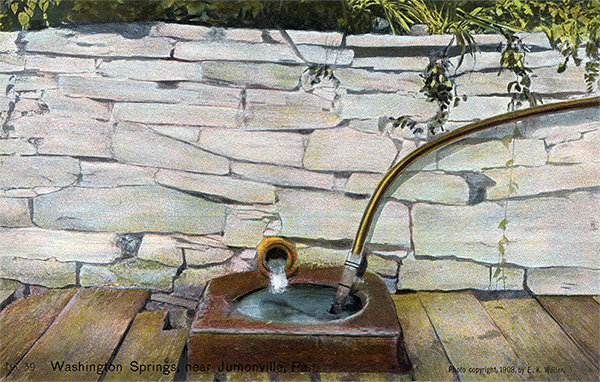 |
Washington Springs, near Jumonville, Pa. Near the Half King's Rocks, and about two miles south of Jumonville is Washington Springs. They were once owned by Thomas Faucet, who some writers claim was the slayer of General Braddock. (See No. 33) [Lacock] |
| |
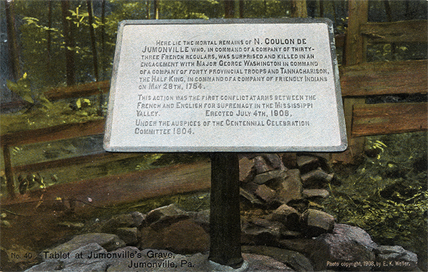 |
Tablet at Jumonville's Grave, Jumonville, Pa. Near this grave are the large rocks on which Washington and the Half King took positions, in their attack on Jumonville, May 28, 1754. This was the initial battle of the French and Indian War. Francis Parkman tersely put it: "Judge it as we may, this obscure skirmish began the war that set the world on fire." [Lacock] |
Footnotes
[45] Orme very accurately and tersely describes this day's march over Keyser Ridge: ''We could not reach our ground till about 7 of the clock, which was three hours later than common, as there was no water, nor even earth enough to fix a tent, between the great Mountain and this place' (Orme Journal, 338).
[46] At this camp, Washington, prostrated by a violent attack of fever, was left under a guard to await the arrival of Dunbar with the rest of the army. That it was really here, and not, as is usually asserted, at Little Meadows or Little Crossings that Washington was left, is clear from his own words. 'We set out [from Little Meadows],' he wrote to his brother on June 28, 'with less than thirty carriages including those that transported the ammunition for the howitzers, twelve-pounders, and six-pounders, and all of them strongly horsed; which was a prospect that conveyed infinite delight to my mind, though I was exceedingly ill at the time. But this prospect was soon clouded, and my hope brought very low indeed, when I found that, instead of pushing on with vigor, without regarding a little rough road, they were halting to level every mole-hill, and to erect bridges over every brook, by which means we were four days in getting twelve miles. At this camp I was left by the Doctor's advice, and the General's positive orders' (Washington, Writings, Sparks ed, II. 82-83).
What Washington says about the length of time spent in marching from Little Meadows helps to fix the location of the camp; for it agrees with Orme's assertion that they left Little Meadows on June 19 and marched from the camp on June 23 (Orme Journal, 336-340). Even in the matter of distance there is a difference of only a mile between the two accounts, and this difference may be so counted for by the fact that Orme always uses the phrase 'we marched about' so many miles. See also Pennsylvania Gazette, July 3, 1755.
[47] See Shippen's manuscript draft of 1759, in the library of the Historical Society of Pennsylvania.
[48] Orme Journal, 340. This camping-ground was reached June 23, 1755. Shippen's draft would seem to confirm the foregoing statements as to the course of the road from Addison to the Youghiogheny. On file, however, in the land office of the Interior Department at Harrisburg, under date of Oct. 8, 1788 is the survey of a tract (also marked Braddock's Old Road) situated near the headwaters of the south branch of Braddock's Run, about one mile south of Addison. This discovery, recently made, necessitates a further examination of the ground in order, if possible, to determine the exact location of the road between the state line and the Youghiogheny.
[49] According to Orme, the Youghiogheny is at this point 'about one hundred yards wide, about three feet deep, with a very strong current' (Orme Journal, 340).
[50] The writer secured from Mr. Thomas an old axe that was found near Braddock Road. There is every reason to believe that it was used by one of Braddock's wood-choppers.
[51] Orme Journal, 341. This camp was about four miles east of Great Meadows, on land now occupied by Albert Landman. Formerly one Job Clark kept a hotel at Twelve Springs on Braddock Road, one mile south of the National turnpike.
[52] Orme Journal, 341. Although the day was fast waning when the cortege passed Fort Necessity, - the place where Washington had the previous year capitulated with the honors of war to Coulon de Villiers, - no stop was made there. This fort, of which some of the outlines still remain, is situated on Meadow Run in Great Meadows, a few hundred yards south of the National turnpike. In 1767 Washington acquired, under the name of Mt. Washington, a tract of 334 acres embracing Fort Necessity. That portion of Great Meadows which includes the old fort is now owned by Lewis Fazenbaker. On July 4, 1908, a very suitable marker was erected to commemorate the battle there.
[53] The grave is enclosed by a board fence, within which are a number of beautiful pine trees. A marker was erected at this point on July 4, 1908. In 1909 a number of spirited citizens of Uniontown, Pa., organized an association known as 'The General Edward Braddock Memorial Park Association.' They have purchased twenty-tour acres of land, Including Braddock's grave, and, in order to preserve to posterity this historic spot, they propose to erect a suitable monument to his memory and otherwise embellish the grounds.
[54] Orme Journal, 343. This orchard, situated about two miles from Fort Necessity and referred to by many writers, must have consisted of crab apple trees at that time. In this camp Braddock died, July 13, 1755.
[55] Owned by Henry Harrison Wiggins.
[56] 'This Indian camp was in a strong position, being upon a high rock with a very narrow and steep ascent to the top. It had a spring in the middle, and stood at the termination of the Indian path to the Monongahela, at the confluence of Red Stone Creek' (Orme Journal, 343). By the aid of this description the writer was able to identify the Half King's Rocks even to the minutest detail.
Previous Page | Next Page | Introduction | Part 1 | Part 2 | Part 3 | Part 4 | Part 5 | Part 6
View user comments below.
No comments have been posted.
Feedback: Do you have corrections or contributions for this page? Want to make a suggestion? Click here to send me an e-mail. I am espcially interested in memories, stories, postcards and photographs. Thanks!

Last updated: 2010-11-05 20:24:39 |
|
|

|
|